


Formation of a dozenal metrological system with minimum change to current measures would suggest retention of scales being used that are already partitioned dozenally and making such units the foundation of an integrated dozenal system.
Quantities which were not successfully reckoned in decimal include angle, where 360 or two-and-a-half square dozen degrees to a circle persist, and time of hours, minutes, and seconds, partly based on sexagesimal or base sixty which is a multiple of twelve. Both of these dimensions have been divided with factors that are familiar to the base twelve. The 360 of angular degrees is suitable for being divisible into twelve sectors of thirty degrees each. The units of time are also suitable for being divided by twelve, such that a twelfth of a day is two hours.
The basis of measurement of time was by division of the periods between the events of illuminating astronomical bodies crossing meridians. This was determined by the revolution of the Earth through the azimuthal angles within the full stellar circle. Application of the dozenal division of angle to the sphere of stars is therefore relevant to accounting of time and further to the division of the terrestrial globe. Hence, let us consider how best to map the stars with a dozenal framework.
There are a number of ways of assigning a system of co-ordinates for mapping the stars. Considered now are those that use fully spherical polar co-ordinates of an azimuthal angle, a polar angle, and a radius, that differ in the orientations of their frames of reference.
1. Equatorial
The equatorial spherical system uses as its polar axis the same axis around which the Earth revolves in its daily rotation. Latitudes and longitudes of stars are matched to latitudes and longitudes on Earth. This system is most useful for timekeeping and navigation on Earth. A disadvantage of this system is that the latitudinal and longitudinal co-ordinates of the stars wander gradually with respect to the Earth by precession of the equinoxes such that the frame of reference needs to be updated with adjustment after several years. For its utility, this system of declination in degrees and right ascension measured in hours is nevertheless how the co-ordinates of stars are most often recorded in astronomical manuals. The direction of the celestial North pole of equatorial co-ordinates is approximated well by the pole star, Polaris. The starting point of the azimuthal angle is reckoned from where the equatorial plane intersects the ecliptic during the Vernal equinox, at "the first point of Aries" in zodiac terminology, now between the constellations Pisces and Aquarius.
2. Ecliptic
This is the zodiac system of astrology. The ecliptic spherical system uses as the polar axis a line perpendicular to the plane of the ecliptic through which the wandering luminaries and the Earth orbit about the Sun. An advantage of this system is that polar angles of the stars do not change with precession of the equinoxes. The system of zodiac star signs has not been updated for millenia and is now no longer aligned with the constellations from which their names are derived. This system can be used in ephemerides and is especially useful for the motions of planets around the ecliptic. The North ecliptic pole is in the constellation Draco.
3. Galactic
This is a Milky Way system. The galactic spherical system of co-ordinates uses the centre of the Milky Way galaxy to determine the starting point of the azimuthal angle and the polar axis. Thus, the Milky Way of greater density of stars goes around the girth of the astral sphere. The centre of the galaxy is directed near the triple point boundary of the constellations Sagittarius, Scorpius, and Ophiuchus. The radial co-ordinates can be used to specify the distances between the Sun of the solar system and the other stars. This system is more suitable for larger scale cosmic dynamics.
In each spherical polar co-ordinate system, the azimuthal angular co-ordinate has the range of a full turn. The polar angular co-ordinate goes from pole to pole and has the range of half a turn. These would be divided dozenally by powers of the base twelve to a full turn.
Map Making
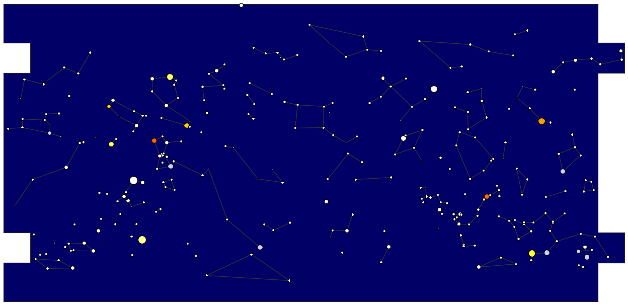
I started making star maps two or three days ago using galactic co-ordinate data of three hundred of the most visible stars, then transformed to equatorial co-ordinates. The horizontal distances are very stretched towards the poles at the top and bottom of this map.
Sinusoidal projection was investigated, which preserves vertical and horizontal angular distances, but distorts oblique distances too much and wastes as unused much space around the corners of the page.
In the main, I have been conservative with joining stars in constellations. Liberties have been taken in some cases to illustrate asterisms or collections of stars that span more than one constellation. For example, I have joined stars of the constellations Sagitta and Lyra to Cygnus.
While the boundaries of constellations are officially set by convention, there is no regulation about how the stars within the boundaries of constellations can be joined. Also, we can be permitted to show commonly identified asterisms. There is therefore scope for rearranging the asterisms so that they better agree with perceptual affinities and psychological conception or for them to fit into a dozenal system of co-ordinates. I would like to see their connections being determined mathematically using graph theoretic principles based on angular distances and apparent brightnesses.
I would be particularly interested in reforming constellations or asterisms near the Southern Pole, where collections of stars appear not to have been connected or named sensibly.
There are not enough stars in this map to show the full pictures of constellations. For example, not all stars forming the fork or hyoid in Taurus after which the Hyades cluster is named are visible.
Colours of some of the brightest stars based on spectral class have been shown. Sizes of the stars give some indication of apparent magnitude.
Reference
http://www.atlasoftheuniverse.com/stars.html
Quantities which were not successfully reckoned in decimal include angle, where 360 or two-and-a-half square dozen degrees to a circle persist, and time of hours, minutes, and seconds, partly based on sexagesimal or base sixty which is a multiple of twelve. Both of these dimensions have been divided with factors that are familiar to the base twelve. The 360 of angular degrees is suitable for being divisible into twelve sectors of thirty degrees each. The units of time are also suitable for being divided by twelve, such that a twelfth of a day is two hours.
The basis of measurement of time was by division of the periods between the events of illuminating astronomical bodies crossing meridians. This was determined by the revolution of the Earth through the azimuthal angles within the full stellar circle. Application of the dozenal division of angle to the sphere of stars is therefore relevant to accounting of time and further to the division of the terrestrial globe. Hence, let us consider how best to map the stars with a dozenal framework.
There are a number of ways of assigning a system of co-ordinates for mapping the stars. Considered now are those that use fully spherical polar co-ordinates of an azimuthal angle, a polar angle, and a radius, that differ in the orientations of their frames of reference.
1. Equatorial
The equatorial spherical system uses as its polar axis the same axis around which the Earth revolves in its daily rotation. Latitudes and longitudes of stars are matched to latitudes and longitudes on Earth. This system is most useful for timekeeping and navigation on Earth. A disadvantage of this system is that the latitudinal and longitudinal co-ordinates of the stars wander gradually with respect to the Earth by precession of the equinoxes such that the frame of reference needs to be updated with adjustment after several years. For its utility, this system of declination in degrees and right ascension measured in hours is nevertheless how the co-ordinates of stars are most often recorded in astronomical manuals. The direction of the celestial North pole of equatorial co-ordinates is approximated well by the pole star, Polaris. The starting point of the azimuthal angle is reckoned from where the equatorial plane intersects the ecliptic during the Vernal equinox, at "the first point of Aries" in zodiac terminology, now between the constellations Pisces and Aquarius.
2. Ecliptic
This is the zodiac system of astrology. The ecliptic spherical system uses as the polar axis a line perpendicular to the plane of the ecliptic through which the wandering luminaries and the Earth orbit about the Sun. An advantage of this system is that polar angles of the stars do not change with precession of the equinoxes. The system of zodiac star signs has not been updated for millenia and is now no longer aligned with the constellations from which their names are derived. This system can be used in ephemerides and is especially useful for the motions of planets around the ecliptic. The North ecliptic pole is in the constellation Draco.
3. Galactic
This is a Milky Way system. The galactic spherical system of co-ordinates uses the centre of the Milky Way galaxy to determine the starting point of the azimuthal angle and the polar axis. Thus, the Milky Way of greater density of stars goes around the girth of the astral sphere. The centre of the galaxy is directed near the triple point boundary of the constellations Sagittarius, Scorpius, and Ophiuchus. The radial co-ordinates can be used to specify the distances between the Sun of the solar system and the other stars. This system is more suitable for larger scale cosmic dynamics.
In each spherical polar co-ordinate system, the azimuthal angular co-ordinate has the range of a full turn. The polar angular co-ordinate goes from pole to pole and has the range of half a turn. These would be divided dozenally by powers of the base twelve to a full turn.
Map Making
I started making star maps two or three days ago using galactic co-ordinate data of three hundred of the most visible stars, then transformed to equatorial co-ordinates. The horizontal distances are very stretched towards the poles at the top and bottom of this map.
Sinusoidal projection was investigated, which preserves vertical and horizontal angular distances, but distorts oblique distances too much and wastes as unused much space around the corners of the page.
In the main, I have been conservative with joining stars in constellations. Liberties have been taken in some cases to illustrate asterisms or collections of stars that span more than one constellation. For example, I have joined stars of the constellations Sagitta and Lyra to Cygnus.
While the boundaries of constellations are officially set by convention, there is no regulation about how the stars within the boundaries of constellations can be joined. Also, we can be permitted to show commonly identified asterisms. There is therefore scope for rearranging the asterisms so that they better agree with perceptual affinities and psychological conception or for them to fit into a dozenal system of co-ordinates. I would like to see their connections being determined mathematically using graph theoretic principles based on angular distances and apparent brightnesses.
I would be particularly interested in reforming constellations or asterisms near the Southern Pole, where collections of stars appear not to have been connected or named sensibly.
There are not enough stars in this map to show the full pictures of constellations. For example, not all stars forming the fork or hyoid in Taurus after which the Hyades cluster is named are visible.
Colours of some of the brightest stars based on spectral class have been shown. Sizes of the stars give some indication of apparent magnitude.
Reference
http://www.atlasoftheuniverse.com/stars.html

» Dozenal Number Words from Metric Prefixes
» Dozenalizing Metric
» Myon Dozenal Nomenclature
» Information per Area of Numerical Forms
» Denominational Dozenal Numerals
» Proto-Indo-European Numbers
» Radix Economy for Alternating Bases
» Graduation Subdivisions